YouTube Video Here: https://www.youtube.com/embed/Qt2GYyGTXTs?feature=oembed&enablejsapi=1 Countless maps suggest that before written history, ancient explorers had an extremely well-developed car
An ancient global-scale ‘mapping project’
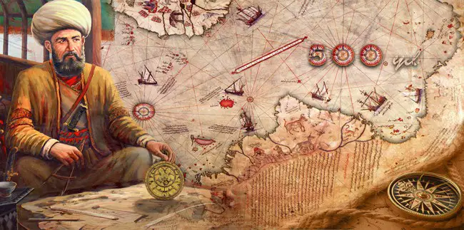
 A look at the ancient Piri Reis map
Piri ReisThe fact that there are maps that depict Antarctica free of Ice, and other parts of the world that were not discovered until recently gives rise to MANY theories—some of them somewhat controversial.
Interestingly, many authors—including myself—will venture out and say that these maps may very well prove that in the distant past, ancient explorers had an extremely well-developed cartography system comparable in precision to the one we have today.
These maps could also ‘prove’ that ancient mankind knew the exact shape and size of the Earth, contrary to popular beliefs, and used spherical trigonometry, precise and elaborate mathematical calculations, as if thousands of years ago an unknown civilization undertook a global-scale project of mapping the entire planet like no one has ever done before. The result: numerous ancient maps that according to many prove our history is not what we’ve been told.
The Zeno Map. Published around 1380, the enigmatic maps accurately depicts the coasts of modern-day countries such as Norway, Sweden, Denmark, Germany, and Scotland. This ancient map also happens to depict—somehow—the EXACT latitude and longitude of a number of islands on our planet.
The Camerio map, created in 1502 uses a spherical grid, even though people in the middle ages still believed our planet was in fact… flat.
The Iehudi Ibn ben Zara map, drawn in 1487 displays remnants of glaciers in Britain. The map also includes extremely detailed depictions of islands in the Mediterranean and Aegean seas. Today, these islands still exist, but due to rising water levels, these are now underwater.
The Hadji Ahmed map, published in 1559, shows incredibly accurate delineations of the western coast of Northern America and Antarctica.
The Buache map—created around 1737— is believed to be the result of much more ancient maps. This chart depicts Antarctica well before the ‘icy’ continent was in fact discovered. Interestingly, like many other ancient maps, this too accurately illustrates Antarctica without ice.
Another shocking map is the King Jaime World Chart. Created in 1502, the map accurately depicts parts of the Sahara Desert displaying it much differently than it is today: with fertile land, huge lakes rivers and what appear to be ancient cities.
The Oronce Finé World Map created in 1534, is an early cordiform chart which displays features of Antarctica when the continent was not covered by Ice.
A look at the ancient Piri Reis map
Piri ReisThe fact that there are maps that depict Antarctica free of Ice, and other parts of the world that were not discovered until recently gives rise to MANY theories—some of them somewhat controversial.
Interestingly, many authors—including myself—will venture out and say that these maps may very well prove that in the distant past, ancient explorers had an extremely well-developed cartography system comparable in precision to the one we have today.
These maps could also ‘prove’ that ancient mankind knew the exact shape and size of the Earth, contrary to popular beliefs, and used spherical trigonometry, precise and elaborate mathematical calculations, as if thousands of years ago an unknown civilization undertook a global-scale project of mapping the entire planet like no one has ever done before. The result: numerous ancient maps that according to many prove our history is not what we’ve been told.
The Zeno Map. Published around 1380, the enigmatic maps accurately depicts the coasts of modern-day countries such as Norway, Sweden, Denmark, Germany, and Scotland. This ancient map also happens to depict—somehow—the EXACT latitude and longitude of a number of islands on our planet.
The Camerio map, created in 1502 uses a spherical grid, even though people in the middle ages still believed our planet was in fact… flat.
The Iehudi Ibn ben Zara map, drawn in 1487 displays remnants of glaciers in Britain. The map also includes extremely detailed depictions of islands in the Mediterranean and Aegean seas. Today, these islands still exist, but due to rising water levels, these are now underwater.
The Hadji Ahmed map, published in 1559, shows incredibly accurate delineations of the western coast of Northern America and Antarctica.
The Buache map—created around 1737— is believed to be the result of much more ancient maps. This chart depicts Antarctica well before the ‘icy’ continent was in fact discovered. Interestingly, like many other ancient maps, this too accurately illustrates Antarctica without ice.
Another shocking map is the King Jaime World Chart. Created in 1502, the map accurately depicts parts of the Sahara Desert displaying it much differently than it is today: with fertile land, huge lakes rivers and what appear to be ancient cities.
The Oronce Finé World Map created in 1534, is an early cordiform chart which displays features of Antarctica when the continent was not covered by Ice.
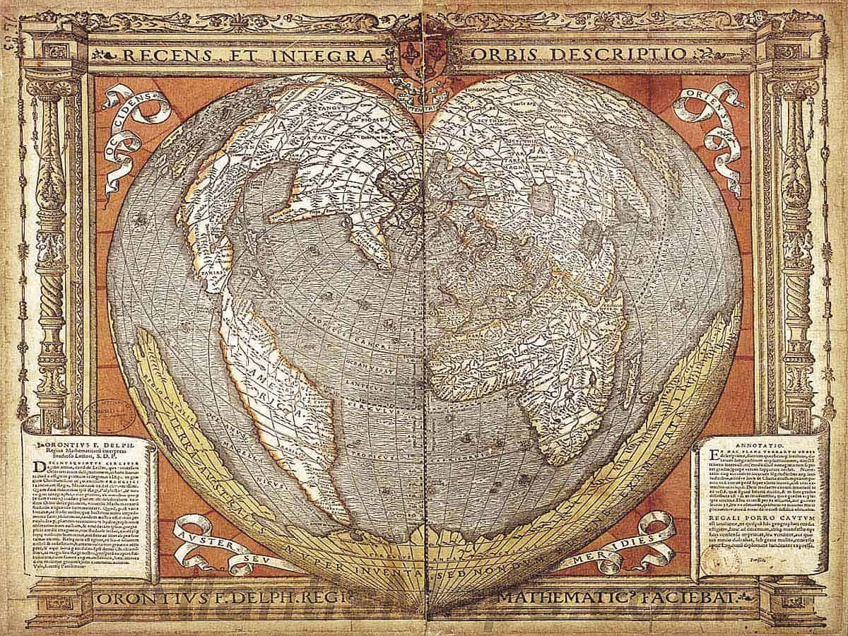 1534: The Oronce Finé World Map. An early cordiform projection which features the Antarctic continent splayed along its southern edge some 300 years before it is believed to have been discovered. An inscription spans the width of the continent, “Southern land newly discovered, but not yet fully explored.”
Just as the Buache map, the Piri Reis Map—one of the most famous ancient charts—is supposedly a collection of even older maps, displaying the correct coastline of Antarctica as it was under the ice. The map was composed around 1520 and in addition to displaying Antarctica without ice, it accurately depicts the geography of the American Continent with such a precision that it looks as if it was put together with the aid of aerial photography.
Is it possible that all of the above maps are the result of an advanced ancient civilization that somehow managed to map the entire planet thousands of years ago—perhaps before the last ice age?
If so, who was this mysterious civilization and does this provide enough ground to venture out and say advanced ancient civilization—like Atlantis—may have existed on Earth, terns of thousands of years ago?
1534: The Oronce Finé World Map. An early cordiform projection which features the Antarctic continent splayed along its southern edge some 300 years before it is believed to have been discovered. An inscription spans the width of the continent, “Southern land newly discovered, but not yet fully explored.”
Just as the Buache map, the Piri Reis Map—one of the most famous ancient charts—is supposedly a collection of even older maps, displaying the correct coastline of Antarctica as it was under the ice. The map was composed around 1520 and in addition to displaying Antarctica without ice, it accurately depicts the geography of the American Continent with such a precision that it looks as if it was put together with the aid of aerial photography.
Is it possible that all of the above maps are the result of an advanced ancient civilization that somehow managed to map the entire planet thousands of years ago—perhaps before the last ice age?
If so, who was this mysterious civilization and does this provide enough ground to venture out and say advanced ancient civilization—like Atlantis—may have existed on Earth, terns of thousands of years ago?
Reference:
Six Ancient Maps that should not exist according to mainstream Scholars
 Unexplained
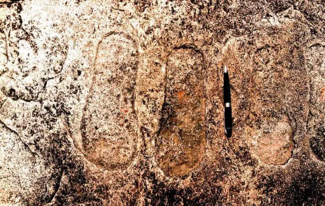
India: Footprints embedded in rock, evidence of ancient astronauts?
Are the footprints embedded in rock in India evidence of ancient astronauts? A village in central India has fueled discussions on numerous social networks about the discovery of a mysterious set of "f
 Unexplained
A researcher Claims to Have Found a 55.000-year-old Artifact Made of Oxygen
In 1990 an Italian "geologist" named Angelo Pitoni was visiting Sierra Leone, in the vicinity of the border with Guinea Conakry, to verify if a certain region of the country known as Kono was indeed,
 Unexplained
The unanswered mysteries of the Anasazi
The great American southwest is considered by many as a place of extremes, ancient people, spirits and legends that even today, inhabit the region. Thousands of years ago, an ancient culture flourishe