Numerous maps have been discovered throughout history that even today remain as an enigma to scholars and skeptics. While most of us are familiar with the work of Piri Reis and his maps, he isn’t the only one to have created charts that remain a mystery to history.
Maps like the one by Piri Reis have been validated by scholars who remain baffled and cannot explain their precision and level of detail. Some of them were created as if somehow, someone was able to see the land from the air before drawing the charts… But remember, some of these maps are thousands of years old, and one, in particular, is even older.
As you go through all of these maps you have to ask yourself just how were these maps made? How is it possible that they display features that were unknown to man according to mainstream history…?
We start off with one of the most enigmatic maps ever discovered…
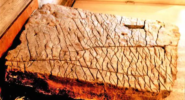
The map of the Creator
The Dashka stone or Map of the Creator is, in fact, a giant stone tablet of unknown origin, discovered in the village of Chandra in Bashkortostan, Russian Federation. What is particularly interesting about this map is its age. According to researchers, the Dashka Stone is believed to be 120 million years old and is a highly detailed map of a specific area of the Ural Mountains, Bashkiria, which has not changed significantly in millions of years. This ancient map is depicted on a scale 1: 1.1 km.
The Piri Reis Map
Another incredible map that according to many should not exist. The Piri Reis map is supposedly a collection of even older maps, displaying the correct coastline of Antarctica as it was under the ice. The map was composed around 1520 and in addition to displaying Antarctica without ice, it accurately depicts the geography of the American Continent with such a precision that it looks as if it was put together with the aid of aerial photography. The perfection and details displayed on the map have been the subject of debate for years among scholars who cannot understand nor explain how this map even exists.
Interestingly, this map was examined by the US Hydrographic Office of the Navy, where its authenticity was confirmed. The map was proven genuine and is so accurate that it was purportedly used to correct errors in some modern maps. The geographical information contained in the map indicates that some of its source material date back more than 5,000 years.
The US Airforce was contacted in 1960 by Professor Charles Hapgood, of Keene College who asked them to review the map and its details. This was their response:
8 RECONNAISSANCE TECHNICAL SQUADRON (SAC)
UNITED STATES AIR FORCE
Westover Air Force Base
MassachusettsReply to Attn of: RTC
6, July, 1960
Subject: Admiral Piri Reis World Map
To: Prof. Charles H. Hapgood
Keene Teachers College
Keene, New HampshireDear Professor Hapgood,
Your request for evaluation of certain unusual features of the Piri Reis World Map of 1513 by this organization has been reviewed.
The claim that the lower part of the map portrays the Princess Martha Coast of Queen Maud Land Antarctic, and the Palmer Peninsula is reasonable. We find that this is the most logical and in all probability the correct interpretation of the map.
The geographical detail shown in the lower part of the map agrees very remarkably with the results of the Seismic profile made across the top of the ice cap by the Swedish-British-Norwegian Antarctic Expedition of 1949.
This indicates the coastline had been mapped before it was covered by the ice-cap.
The ice-cap in this region is now about a mile thick. We have no idea how the data on this map can be reconciled with the supposed state of geographical knowledge in 1513.
Harold Z. Ohlmeyer
Lt. Colonel, USAF
Commander(source)
Shortly after, another interesting letter was sent by the USAF:
8 RECONNAISSANCE TECHNICAL SQUADRON (SAC)
UNITED STATES AIR FORCE
Westover Air Force Base, Mass.14 Aug 61
Mr. Charles H. Hapgood
Keene Teachers College
Keene, N.H.Dear Professor Hapgood:
It is not very often that we have an opportunity to evaluate maps of ancient origin. The Piri Reis (1513) and Oronteus Fineaus [sic] (1531) maps sent to us by you, presented a delightful challenge, for it was not readily conceivable that they could be so accurate without being forged. With added enthusiasm we accepted this challenge and have expended many off duty hours evaluating your manuscript and the above maps. I am sure you will be pleased to know we have concluded that both of these maps were compiled from accurate original source maps, irrespective of dates. The following is a brief summary of our findings:
- The solution of the portolano projection used by Admiral Piri Reis, developed by your class in Anthropology, must be very nearly correct; for when known geographical locations are checked in relationship to the grid computed by Mr. Richard W. Strachan (MIT), there is remarkably close agreement. Piri Reis’ use of the portolano projection (centered on Syene, Egypt) was an excellent choice, for it is a developable surface that would permit the relative size and shape of the earth (at that latitude) to be retained. It is our opinion that those who compiled the original map had an excellent knowledge of the continents covered by this map.
- As stated by Colonel Harold Z. Ohlmeyer in his letter (July 6, 1960) to you, the Princess Martha Coast of Queen Maud Laud, Antarctica, appears to be truly represented on the southern sector of the Piri Reis map. The agreement of the Piri Reis Map with the seismic profile of this area made by the Norwegian-British-Swedish Expedition of 1949, supported by your solution of the grid, places beyond a reasonable doubt the conclusion that the original source maps must have been made before the present Antarctic ice cap covered the Queen Maud Land coasts.
- It is our opinion that the accuracy of the cartographic features shown in the Oronteus Fineaus [sic] Map (1531) suggests, beyond a doubt, that it also was compiled from accurate source maps of Antarctica, but in this case of the entire continent. Close examination has proved the original source maps must have been compiled at a time when the land mass and inland waterways of the continent were relatively free of ice. This conclusion is further supported by a comparison of the Oronteus Fineaus [sic] Map with the results obtained by International Geophysical Year teams in their measurements of the subglacial topgraphy. The comparison also suggests that the original source maps (compiled in remote antiquity) were prepared when Antarctica was presumably free of ice. The Cordiform Projection used by Oronteus Fineaus [sic] suggests the use of advanced mathematics. Further, the shape given to the Antarctic continent suggests the possibility, if not the probability, that the original source maps were compiled on a stereographic or gnomic type of projection (involving the use of spherical trigonometry).
- We are convinced that the findings made by you and your associates are valid, and that they raise extremely important questions affecting geology and ancient history, questions which certainly require further investigation.
We thank you for extending us the opportunity to have participated in the study of these maps. The following officers and airmen volunteered their time to assist Captain Lorenzo W. Burroughs in this evaluation: Captain Richard E. Covault, CWO Howard D. Minor, MSgt Clifton M. Dover, MSgt David C. Carter, TSgt James H. Hood, SSgt James L. Carroll, and A1C Don R. Vance.
LORENZO W. BURROUGHS
Captain, USAF
Chief, Cartographic Section
8th Reconnaissance Technical Sqdn (SAC)
Westover Air Force Base, Massachusetts(source)
The Zeno Map was drawn circa 1380
This incredible map that predates the Piri Reis map outlines the coast of modern-day Norway, Sweden, Denmark, Scotland, and Germany. In addition to that, the Zeno maps just happen to include the exact longitude and latitude of a number of islands. Why is this important? Well, it is because in order to determine longitude you would need to use a chronometer, a device that was invented in 1765. Even more incredibly, the Zeno Map appear to depict the topography of modern-day Greenland free of glaciers which means that someone had to have seen Greenland prior to the ice age. This map is one of the most enigmatic discoveries which make you question nearly everything you have been told about history as we know it.
But there are more maps that are equally shocking as the ones mentioned above
Iehudi Ibn ben Zara map
Drawn somewhere around 1487, the Iehudi Ibn ben Zara map shows certain regions of Britain covered in Glaciers. The map also displays islands in the Mediterranean and Aegean seas. These islands exist still today, only underwater.
Hamy King Char
Another incredible map drawn in 1502 shows northern Siberian Rivers emptying into the Arctic Ocean. This enigmatic chart happens to depict the ancient Suez Canal and numerous Asian Islands that are now joined to land.
The King Jaime World Chart
Another map that is completely baffling is the King Jaime World Chart which depicts the Sahara desert as a fertile land with huge lakes, rivers, and cities. We know that in the distant past, the Sahara was one of the most fertile regions on Earth.
As you can see, there are several maps that point towards a very different story about the past of mankind than what mainstream books are telling us.
The above-mentioned maps are evidence that suggest many things. First of all, it would mean that in the distant past, somehow, someone organized a giant effort to perform a global survey of our planet. The above-mentioned maps are most likely result of that survey. Ancient mankind most likely used advanced instruments that allowed them to measure latitude and longitude thousands of years ago. This points to the existence of know lost advanced ancient technology. In addition to the instruments and efforts, it is very likely that ‘prehistoric people’ were much more advanced than what mainstream scholars believe. These ancient peoples used sophisticated formulas of trigonometry and mathematical measurements which allowed them to accurately depict, on maps, certain areas of our planet. But perhaps what is most important of all of the above, is the fact that ancient mankind knew, thousands of years ago the correct shape and size of planet Earth.
Updated to properly source the content 11/18/2015
Source Source and A BIG THANKS to our Facebook fan Justin Neddo for his contribution


